🚧 EARLS COLNE ROAD CLOSURE – 2026 PHASED WORKS UPDATE
Works Start Date: 19 January 2026
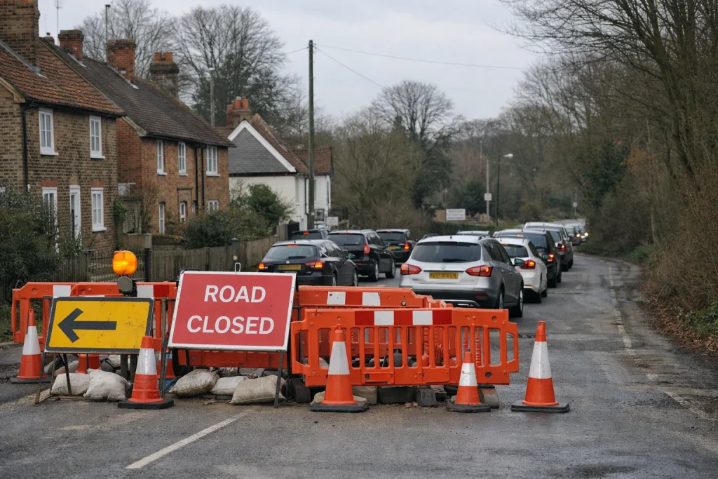
What’s Happening: Essential gas main replacement by Cadent is causing phased closures across Church Hill, Upper Holt Street, Lower Holt Street and Colneford Hill.
The 2026 Earls Colne road closure programme will continue through April, with full and partial closures affecting through traffic, bus services and local access as works move in phases.
📌 Quick Summary: Church Hill closed 26 Jan–16 Feb; Upper Holt Street from 16 Feb (37 days); Lower Holt Street from 2 March (30 days).
🚌 Transport Impact: Services 88/88A/88B diverted via A12, A120 and B1024, with some stops not served.
⏳ Project Duration: Multi-phase works scheduled through April 2026, subject to progress.
At-a-Glance Overview:
- Overall Programme: 19 January – April 2026
- Primary Roads Affected: Church Hill, Upper Holt Street, Lower Holt Street, Colneford Hill
- Legal Basis: Road Traffic Regulation Act 1984 – Section 14(1)
- Live Updates: one.network & Essex Highways roadworks map
- Emergency Gas Number: 0800 111 999
These essential works aim to secure a reliable gas supply, but temporary disruption is unavoidable while replacement takes place.
What Is the Earls Colne Road Closure in 2026, and Why Is It Happening?
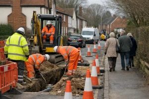
The 2026 Earls Colne road closure scheme is part of essential gas main replacement works carried out by Cadent.
The project involves replacing approximately 1,000 metres of ageing gas pipes between Earls Colne and White Colne to ensure a safe and reliable supply for homes and businesses.
These works are being delivered in multiple phases under the Road Traffic Regulation Act 1984 – Section 14(1), which allows temporary traffic regulation orders where necessary for public and workforce safety.
As Cadent explained:
“We have a responsibility to make sure every property that uses gas has access to it 24/7, 365 days a year.”
While disruptive, the works are classified as essential infrastructure upgrades designed to prevent future faults and emergency callouts.
Why Full Closures Are Sometimes Necessary?
Although two-way temporary traffic lights were initially expected in some phases, full closures were implemented in certain areas due to safety concerns. Heavy plant equipment, deep excavations, and restricted carriageway widths made it impractical to safely accommodate through traffic.
Cadent also noted:
“Sometimes the diversion can appear longer, but that is to ensure traffic continues to flow without causing any further disruption.”
In practical terms, you may experience longer diversion routes, but these are selected for vehicle suitability and road safety.
When Are the Earls Colne Road Closures Happening in 2026?
The project commenced on 19 January 2026 and is expected to continue in carefully managed phases until April 2026, subject to progress on site, safety considerations and weather conditions.
Because the works involve deep excavation and pipe replacement, timelines may adjust slightly as each phase progresses.
Below is a consolidated timeline based on official notices, Temporary Traffic Regulation Orders, and public updates from Essex Highways and local communications.
Earls Colne Road Closure Timeline 2026
| Road / Area | Start Date | Expected Duration | Notes |
| Church Hill | 26 January 2026 | Until approx. 16 February 2026 | Closed to through traffic; residential access maintained |
| Upper Holt Street | 16 February 2026 | 37 days | Official Temporary Traffic Regulation Order |
| Lower Holt Street | 2 March 2026 | 30 days | Closure for gas main replacement |
| Colneford Hill | Phased in early 2026 | Part of the overall programme | Affected during later phases |
| Overall Programme | 19 January 2026 | Through April 2026 | Multi-phase works |
How Long Will the Overall Scheme Last?
The works are structured in nine phases, progressing through key connecting roads, including:
- Church Hill
- Upper Holt Street
- Lower Holt Street
- Colneford Hill
- Coggeshall Road
While the aim is to complete by April 2026, closures may shift depending on progress. In earlier phases, working hours were reportedly increased to accelerate pipe replacement and shorten disruption periods.
Which Roads and Areas Are Affected by the Earls Colne Road Closure?
The primary roads directly impacted by the Earls Colne road closure programme include:
- Church Hill (A1124 corridor)
- Upper Holt Street
- Lower Holt Street
- Colneford Hill (White Colne connection)
These roads form critical links between Earls Colne, White Colne, Halstead and Colchester, meaning closures have a ripple effect across the wider local network.
However, diversion routes and redirected traffic are also affecting surrounding roads, including:
- High Street
- Halstead Road
- Stonebridge Hill
- Parley Beams
- Colchester Road
- Stanstead Hall Road
Drivers have reported congestion on smaller rural roads, particularly during morning and late-afternoon peak hours, where carriageways are narrower and passing points limited.
Church Hill – A Key Arterial Route
Church Hill is one of the most strategically important roads in the area. It links Halstead and Colchester along the A1124 and provides direct access to:
- Earls Colne High Street
- Essex Golf and Country Club
- Local residential estates
- Bus stops including Temperance Yard, The Lion and Station Road
During closure phases, Church Hill has been restricted to residential access only, with through traffic diverted onto signed alternative routes.
Because this section normally carries a steady flow of commuter and commercial vehicles, its closure has been particularly noticeable.
How Will the Earls Colne Road Closure Affect Traffic, Parking and Daily Journeys?
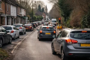
If you drive through Earls Colne regularly, you should expect noticeable delays, particularly at peak commuting times.
Reported impacts include:
- Increased congestion on rural diversion roads
- Vehicles using narrow lanes not designed for heavy traffic
- Occasional reports of soft verges giving way
- Reduced passing trade for High Street businesses
A local councillor commented:
“I feel really sorry for the motorists who are struggling to just go about their normal journeys.”
Traffic Impact Overview:
| Impact Area | What You Can Expect | Recommended Action |
| Peak hours | Slower journey times | Allow 15–30 extra minutes |
| School runs | Localised congestion | Consider alternative drop-off times |
| Rural lanes | Limited passing space | Avoid unsuitable back routes |
| High Street | Reduced through traffic | Support local businesses where possible |
If you rely on punctual travel, for work, school, or appointments, planning ahead is essential.
What Diversion Routes Are in Place During the Roadworks?
Diversion routes vary depending on the specific phase of the project, but several key strategic roads have been used consistently to maintain safe traffic movement.
These include:
- A12
- A120
- B1024 Coggeshall Road
- A131
- Routes through Colne Engaine and Braintree during certain phases
While some diversions may appear lengthy on a map, they are designed to accommodate larger vehicles safely and avoid unsuitable narrow lanes. In infrastructure projects of this scale, diversion suitability is prioritised over the shortest distance.
General Diversion Routing Summary:
| Closed Section | Main Diversion Roads | Notes |
| Church Hill | A12 → A120 → B1024 | Reconnects to Earls Colne |
| Upper Holt Street | Local signed diversion | Phase-specific routing |
| Lower Holt Street | A131 & surrounding network | Subject to change |
For the most accurate and up-to-date routing information, the live one. network map is strongly recommended.
The Essex Highways roadworks map streams directly from this system and allows you to adjust date filters beyond the default two-week view to check future phases.
How Are Bus Services Affected by the Earls Colne Road Closure?
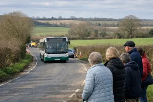
Public transport has been significantly impacted, particularly services linking Colchester, Halstead, and surrounding villages.
Services 88 / 88A / 88B
These services have been diverted via:
- A12
- A120
- B1024
As a result, stops on Church Hill and Lower Holt Street have not been served during certain phases. Some journeys resume normal routing once clear of the works area.
Evening and Sunday services may operate under a different provider contract and could follow alternative diversions.
Services 82 / 82A / 82B and Shuttle Arrangements
During phases where Colne Engaine was temporarily isolated from the main route, a shuttle service funded by Essex County Council was introduced to maintain connectivity between Earls Colne and Colne Engaine.
Passengers are advised to:
- Check operator service updates before travelling
- Track live vehicle movements where available
- Allow additional journey time
- Confirm return journey timings in advance
Bus operators have confirmed that they will continue issuing updates as the works progress, recognising that flexibility is essential during a phased infrastructure scheme.
How Will Local Businesses and Residents Be Affected?
Businesses along the High Street have reported reduced through traffic, which directly impacts passing trade. Some motorists have chosen to avoid the village entirely during closure periods.
However, residential access has generally been maintained, although with restricted vehicle flow and occasional waiting times.
You may notice:
- Increased noise from diverted vehicles
- Temporary parking pressure
- Delivery timing adjustments
While frustrating, the intention is to ensure long-term infrastructure reliability for the area.
Where Can You Check Live Updates About the Earls Colne Road Closure?

As the Earls Colne road closure programme is being delivered in phased stages, updates can occur with little notice, making it essential to consult official sources before setting out on your journey.
Relying on accurate, real-time information will help you avoid unnecessary delays and better plan alternative routes.
The most reliable sources include:
- network live roadworks map
- Essex Highways future roadworks map
- Earls Colne Parish Council updates
- Konectbuses service update pages
The default online roadworks map typically displays a two-week window of activity. To view later phases extending into March or April, you may need to manually adjust the date filter for a broader timeframe.
What Should You Do If You Smell Gas Near the Works?
Although the 2026 works are planned engineering operations, safety remains the highest priority throughout the project.
If you detect the smell of gas at any time, whether near Church Hill, Upper Holt Street, Lower Holt Street or elsewhere in the village, you should treat it as a genuine emergency.
Cadent’s guidance is clear:
“If you smell gas, always ring the National Gas Emergency Service immediately on 0800 111 999.”
You should not assume that any unusual smell is related to the scheduled works. Gas leaks can occur independently and must always be investigated urgently. If possible, move to fresh air, avoid using electrical switches or naked flames, and contact the emergency number without delay.
Prompt reporting ensures that engineers can assess the situation quickly and take appropriate action. While infrastructure upgrades are designed to improve long-term safety and reliability, immediate vigilance from residents plays an important role in protecting the community throughout the project.
Conclusion
The Earls Colne road closure programme in 2026 is a major but temporary disruption caused by essential gas main replacement works.
While the phased closures of Church Hill, Upper Holt Street and Lower Holt Street have created significant traffic and public transport challenges, the long-term objective is a safer, more reliable infrastructure network.
If you travel through the area regularly, you should:
- Plan ahead
- Check live updates
- Allow extra time
- Follow official diversion signage
By staying informed and flexible, you can minimise disruption to your daily routine while these critical upgrades are completed.
Frequently Asked Questions
Will emergency services still have access during closures?
Yes. Emergency access is maintained throughout all phases, even when roads are closed to through traffic.
Are cyclists and pedestrians allowed through the closure points?
Access varies depending on safety conditions. In most cases, pedestrian access is maintained, but always follow on-site signage.
Could the completion date extend beyond April 2026?
While April is the current target, delays due to weather or technical challenges could extend timelines.
Are school bus services guaranteed to operate normally?
School services have been prioritised where possible, but temporary diversions may still apply.
Why can’t temporary traffic lights be used instead of full closures?
In certain sections, carriageway width and excavation depth make it unsafe to maintain two-way traffic.
Will road surfaces be fully reinstated after works finish?
Yes. Reinstatement work is part of the project, ensuring road surfaces are restored to required standards.
Can you claim compensation for business losses due to roadworks?
Compensation policies vary and are subject to council and utility provider frameworks.
{
“@context”: “https://schema.org”,
“@graph”: [
{
“@type”: “FAQPage”,
“mainEntity”: [
{
“@type”: “Question”,
“name”: “Will emergency services still have access during closures?”,
“acceptedAnswer”: {
“@type”: “Answer”,
“text”: “Yes. Emergency access is maintained throughout all phases, even when roads are closed to through traffic.”
}
},
{
“@type”: “Question”,
“name”: “Are cyclists and pedestrians allowed through the closure points?”,
“acceptedAnswer”: {
“@type”: “Answer”,
“text”: “Access varies depending on safety conditions. In most cases, pedestrian access is maintained, but always follow on-site signage.”
}
},
{
“@type”: “Question”,
“name”: “Could the completion date extend beyond April 2026?”,
“acceptedAnswer”: {
“@type”: “Answer”,
“text”: “While April is the current target, delays due to weather or technical challenges could extend timelines.”
}
},
{
“@type”: “Question”,
“name”: “Are school bus services guaranteed to operate normally?”,
“acceptedAnswer”: {
“@type”: “Answer”,
“text”: “School services have been prioritised where possible, but temporary diversions may still apply.”
}
},
{
“@type”: “Question”,
“name”: “Why can’t temporary traffic lights be used instead of full closures?”,
“acceptedAnswer”: {
“@type”: “Answer”,
“text”: “In certain sections, carriageway width and excavation depth make it unsafe to maintain two-way traffic.”
}
},
{
“@type”: “Question”,
“name”: “Will road surfaces be fully reinstated after works finish?”,
“acceptedAnswer”: {
“@type”: “Answer”,
“text”: “Yes. Reinstatement work is part of the project, ensuring road surfaces are restored to required standards.”
}
},
{
“@type”: “Question”,
“name”: “Can you claim compensation for business losses due to roadworks?”,
“acceptedAnswer”: {
“@type”: “Answer”,
“text”: “Compensation policies vary and are subject to council and utility provider frameworks.”
}
}
]
},
{
“@type”: “BlogPosting”,
“mainEntityOfPage”: {
“@type”: “WebPage”,
“@id”: “https://www.prestonblog.co.uk/earls-colne-road-closure/”
},
“author”: {
“@type”: “Person”,
“name”: “Jennifer ”
},
“publisher”: {
“@type”: “Organization”,
“name”: “Preston Blog “,
“logo”: {
“@type”: “ImageObject”,
“url”: “https://www.prestonblog.co.uk/wp-content/uploads/2025/12/Preston-Blog-Logo.png”
}
},
“headline”: “Earls Colne Road Closures 2026 Updates | Timeline, Traffic Impact and Routes”,
“image”: “https://www.prestonblog.co.uk/wp-content/uploads/2026/02/Earls-Colne-Road-Closures-2026-Updates.webp”,
“datePublished”: “2026-02-20”,
“dateModified”: “2026-02-20”
}
]
}

